Peter's Brewery Map Quiz
This is a quiz with a theme - each of the map extracts is also the location of an independent real ale brewery, which may help you to work out where they are. All but two of them are listed on the website of the Independent Family Brewers of Britain.
The quiz contains 20 OS map extracts, all taken from current on-line mapping. All you need to do is identify them. Send your answers to me by e-mail.
They are all at the same scale, north is always at the top, and most identifying text has been removed. Some are easy, some are much harder, so e-mail me with the ones you know. Comments have now been added for all the pictures.
Most of the maps are of villages or market towns, although a few are part of larger urban areas. With the exception of one in Scotland and one in Wales, all are in England.
I have now added the answers to the questions.
Thanks to everyone for taking part.
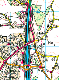
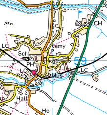
Question 1
A N-S primary A-road turns to motorway. There aren't a lot of places where this happens. The original route seems to run to the west.
This is Gale's of Horndean in Hampshire.
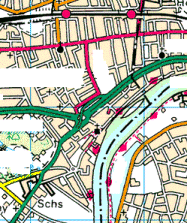
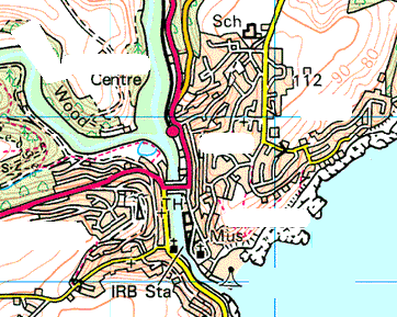
Question 2
A large, tidal river running through a densely built up area. The junction has a distinctive flyover. This one shouldn't be too difficult.
Fuller's of Chiswick, West London.
Question 3
Probably the most difficult of the set. A non-primary A-road runs north-eastwards from a large industrial town which in the past was famed for the manufacture of saucepans. One of the two that isn't in England.
Felinfoel, on the Northern outskirts of Llanelli, Carmarthenshire.
Question 4
A tidal river, flowing to the south, cutting through steep hills, and a bypass in tunnel. There's only one town in the UK with a layout remotely like this.
Harvey's of Lewes, East Sussex.
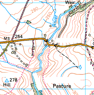
Question 5
This one is virtually at sea level, with a spot height of 3 metres. The windmill is a distinctive feature. The combination of railway and straight, modern single-carriageway bypass should help to locate it,
Bateman's of Wainfleet, Lincolnshire.
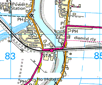
Question 6
Note the tidal creek at the north of the map extract. The road running diagonally across the bottom is very straight - perhaps originally built by the Romans?
Shepheard Neame, Faversham, Kent.
Question 7
A primary route bypass that tucks closely in to a fair-sized market town with a T-shaped plan. The river drains to the south, and the spot heights suggest we are near the sea.
Palmer's of Bridport, Dorset.

Question 8
A small east-coast seaside resort accessed by a dead-end A-road, with a lighthouse in its centre. This should be easy to identify.
Adnams of Southwold, Suffolk.

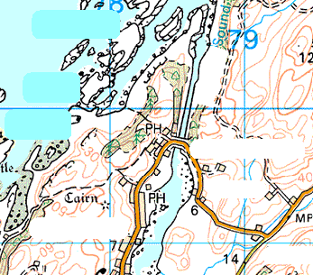
Question 9
A rocky, north-facing coast, with a partly dual primary bypass running to the south, and a railway line. The bypass has been further upgraded since this map extract. The brewery takes its name from a district of the town to the north-west.
Belhaven, Dunbar, East Lothian.
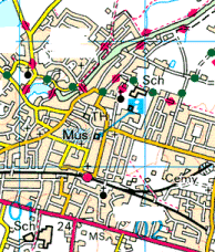
Question 10
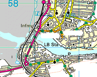
A dense urban area, with a primary north-south route including an aborted GSJ. This is the main southern access to a large city.
Hyde's of Moss Side, Manchester,
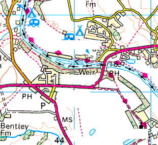
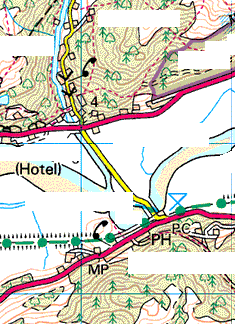
Question 11
Two A-roads, one primary, plus a B-road, fan out from a junction. The countryside is very open, with few woods and trees. Note the spot heights - this is high, windswept country. The brewery is in a rural location west of the red A-road.
Donnington Brewery, in the Costwolds near Stow-on-the-Wold, Gloucestershire.
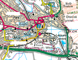
Question 12
This busy market town has a very distinctive plan in concentric circles around its castle. The canal has recently been restored to navigation and has a very long flight of locks descending a hill just to the west.
Wadworth's of Devizes, Wiltshire.

Question 13
Looks like the southern outskirts of a large Northern town, with road and railway climbing up a valley in hilly country. The railway is not part of Network Rail.
Timothy Taylor, Keighley, West Yorkshire.
Question 14
A sprawling town with a southern bypass. The E-W railway has some sharp curves for a main line. This is one of the less picturesque locations in a popular tourist area.
St Austell Brewery in the town of the same name in Cornwall.
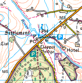
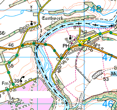
Question 15
A very small town, hardly more than a village, set amongst broad acres in a rural area. The river flows from NW to SE. The marked Visitor Centre has a brewery connection. Some may consider this is a rather peculier place.
Masham in North Yorkshire, home to both Theakston's and Black Sheep.
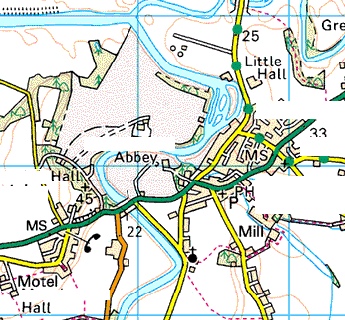
Question 16
A market town where the river runs through expansive parkland. The town was comprehensively rebuilt in the 18th century following a major fire and is regarded as one of Britain's finest Georgian townscapes.
Hall & Woodhouse (aka the Badger Brewery), Blandford Forum, Dorset.
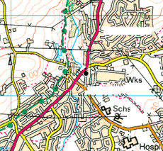
Question 17
One of the harder ones - the number of disused railways suggests an area once busy with industry. The bypass to the south has some sharp curves and has recently been subject to a controversial reduced speed limit.
Hardys & Hansons, Kimberley, Nottinghamshire.
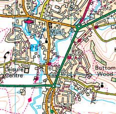
Question 18
A large village set off the beaten track in open agricultural country, with a disused railway running to the east. Note from the spot height that it is over 500 feet above sea level. Where are there large expanses of countryside at such heights?
Hook Norton Brewery, of the village of the same name in North Oxfordshire.
Question 19
A sizeable market town with a complex plan, bypassed to the south. The camping sites suggest a popular tourist area. The river flows towards the west. A famous poet was born here.
Jennings of Cockermouth, Cumbria, birthplace of William Wordsworth. This brewery was the subject of a takeover bid by Wolverhampton & Dudley last week.
Question 20
One of the more difficult ones - an industrial area with a canal and main-line railway running through it. Although both are north-south on this extract, their general course is actually east-west. The railway carries a busy passenger service although the station at this location, which had "Junction" in its title, has been closed for many years. Note the local government boundary. There's a tiny sliver of motorway blue at the bottom left of the extract.
J. W. Lees of Middleton Junction, near Oldham, Greater Manchester.